Image

Project Number
Integrated Water Resource Management and Ecosystem-based Adaptation (EbA) in the Xe Bang Hieng River Basin and Luang Prabang City
Project Status
Finished
Project Date
Project category
Activity 03
Project Area of Work
Component 03: Knowledge Management and ME
Project Donor & Co-financing
UNDP/GEF-LDCF
Project Contact Details
For more information, please contact:
Phouphet Chittaphone
Database Management and Communication Officer IWRM-EbA Project
Email: [email protected]
Phouphet Chittaphone
Database Management and Communication Officer IWRM-EbA Project
Email: [email protected]
Share:


Survey and Assessment of Degraded Forest Areas for Restoration"
Project Location
"Ban Kengtha Mae, Kenghoua Pa, and Sop Salu, Xepon District, Savannakhet Province, Lao PDR, from October 28 to November 9, 2024."
Project Description
The Integrated Water Resources Management and Ecosystem-Based Adaptation (IWRM-EbA) Project in the Xe Bang Hieng River Basin and Luang Prabang City aims to manage and restore riparian forests to address flood and drought challenges. The project focuses on three target villages in Sepon District—Ban Keng Tham, Ban Keng Hua Pa, and Ban Sop Slu—due to their rich natural resources and diverse environments, which are essential for preserving natural water sources, supporting livelihoods, and maintaining aquatic ecosystems. Over the years, riparian forests, including protected and protective forest areas, have suffered significant degradation due to human activities and natural disasters. To conserve and restore these vital resources, it is necessary to identify and survey degraded areas as a first step toward effective management and restoration.
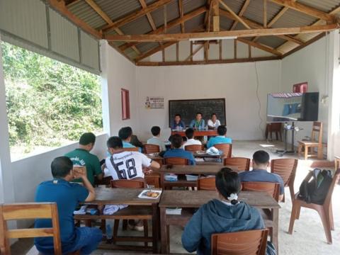
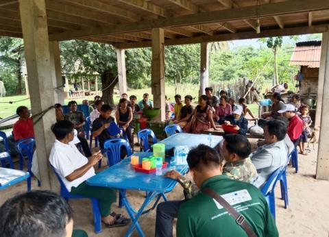
From October 28 to November 9, 2024, a consultation meeting was held at the Agriculture and Forestry Office in Sepon District to discuss the survey of degraded forest areas in the three target villages. The meeting was chaired by Mr. Sombath Itthavong, Deputy Mayor of Sepon District, along with the district project steering committee. Participants included representatives from the Ministry of Natural Resources and Environment (Water Resources Department), the Ministry of Agriculture and Forestry (Forestry Department), provincial departments such as the Department of Natural Resources and Environment (Water Resources and Hydrometeorology Sector), and the Department of Agriculture and Forestry (Forestry Sector and Protected Forest Management). Additionally, Savannakhet Province field project staff, district-level offices, including the District Administration Office, Natural Resources and Environment Office, and Agriculture and Forestry Office, as well as village cluster offices from the target villages, were present. Village authorities, community members, and parents from the three target villages also participated, bringing the total number of attendees to 356, including 71 women. Following the meeting, a field survey was conducted in the three target villages and neighboring areas to identify and document degraded forest areas for restoration initiatives.
From October 28 to November 9, 2024, a consultation meeting was held at the Agriculture and Forestry Office in Sepon District to discuss the survey of degraded forest areas in the three target villages. The meeting was chaired by Mr. Sombath Itthavong, Deputy Mayor of Sepon District, along with the district project steering committee. Participants included representatives from the Ministry of Natural Resources and Environment (Water Resources Department), the Ministry of Agriculture and Forestry (Forestry Department), provincial departments such as the Department of Natural Resources and Environment (Water Resources and Hydrometeorology Sector), and the Department of Agriculture and Forestry (Forestry Sector and Protected Forest Management). Additionally, Savannakhet Province field project staff, district-level offices, including the District Administration Office, Natural Resources and Environment Office, and Agriculture and Forestry Office, as well as village cluster offices from the target villages, were present. Village authorities, community members, and parents from the three target villages also participated, bringing the total number of attendees to 356, including 71 women. Following the meeting, a field survey was conducted in the three target villages and neighboring areas to identify and document degraded forest areas for restoration initiatives.
Project Outcomes & Impacts
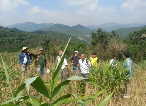
After the chairman of the meeting outlined the objectives and officially opened the session, he invited Mr. Sinuan Xaythany, Deputy Director of the District Agriculture and Forestry Office, to present the plan for surveying and defining the boundaries of degraded forests. This plan included the creation of maps to delineate forest boundaries, including watershed areas, for Keng Tham, Keng Hua Pa, and Sop Salu villages, as well as the surrounding areas in Sepon District.
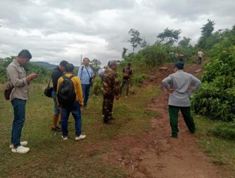
Following the presentation, participants engaged in a productive discussion, offering valuable feedback on the survey process. They provided direct input on how to define the boundaries of various forest types and agreed on using GPS tools to capture the coordinates of these boundaries. This would allow for the creation of detailed maps showing the boundaries of forests and the areas designated for restoration. In total, 173.48 hectares of forest were identified for restoration within the target villages and surrounding regions. The participants also defined the boundaries of degraded forest areas, aiming to ensure sustainable forest management and protection. After comprehensive discussions, the village authorities, elders, and community members reached a unanimous agreement, summarized as follows:
1. Keng Hua Pa Village: This area includes part of Phu Soun Provincial Park and Dong Phu Soun National Park, along with a 117.23-hectare riverbank forest restoration area. The area also encompasses upland rice fields designated for reforestation. Two boundary markers were established: Area 1 contains 86 markers, and Area 2 includes 24 markers, with signs installed at key locations.
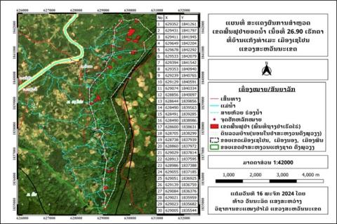
2. Keng Tham Village: The land here includes part of Dong Phu Vieng National Park and features a 26.90-hectare riverbank forest restoration area, along with upland rice fields set for reforestation. A total of 30 boundary markers and signs were installed to demarcate the area.
3. Sop Salu Village: This village includes the Phu Kruang area, a riverine forest restoration area covering 26.35 hectares, with upland rice fields designated for reforestation. A total of 29 boundary markers and signs were installed to clearly define the restoration area.
Following the presentation, participants engaged in a productive discussion, offering valuable feedback on the survey process. They provided direct input on how to define the boundaries of various forest types and agreed on using GPS tools to capture the coordinates of these boundaries. This would allow for the creation of detailed maps showing the boundaries of forests and the areas designated for restoration. In total, 173.48 hectares of forest were identified for restoration within the target villages and surrounding regions. The participants also defined the boundaries of degraded forest areas, aiming to ensure sustainable forest management and protection. After comprehensive discussions, the village authorities, elders, and community members reached a unanimous agreement, summarized as follows:
1. Keng Hua Pa Village: This area includes part of Phu Soun Provincial Park and Dong Phu Soun National Park, along with a 117.23-hectare riverbank forest restoration area. The area also encompasses upland rice fields designated for reforestation. Two boundary markers were established: Area 1 contains 86 markers, and Area 2 includes 24 markers, with signs installed at key locations.
2. Keng Tham Village: The land here includes part of Dong Phu Vieng National Park and features a 26.90-hectare riverbank forest restoration area, along with upland rice fields set for reforestation. A total of 30 boundary markers and signs were installed to demarcate the area.
3. Sop Salu Village: This village includes the Phu Kruang area, a riverine forest restoration area covering 26.35 hectares, with upland rice fields designated for reforestation. A total of 29 boundary markers and signs were installed to clearly define the restoration area.
Project Media & Reports
Image
Image
Image
Image
Image
Image
Image